The transition between major climate drivers is reaching a critical juncture today, February 16, 2026, as the multi-year La Niña pattern that dominated recent seasons officially enters its final decay phase. With sea surface temperatures in the central tropical Pacific now rising toward neutral thresholds, meteorologists are closely monitoring the emerging potential for an El Niño event to take hold by the second half of the year. This shift in the Australia climate carries significant weight for the nation’s primary producers and water managers, as the reversal of oceanic temperatures often marks the beginning of prolonged dry spells and elevated heat across the eastern and southern states. While the immediate forecast remains settled, the developing signals in both the Pacific and Indian Oceans suggest a fundamental change in weather patterns is on the horizon.
Table of Contents
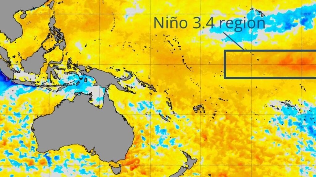
The Dual Threat of El Niño and the Indian Ocean Dipole
The potential for a dry 2026 is not solely dependent on Pacific conditions; it is also linked to the Indian Ocean Dipole (IOD). Current long-range modeling indicates a growing probability that a positive IOD phase could develop in tandem with El Niño during the winter months. When these two climate drivers enter their respective warm and dry phases simultaneously, they act as a force multiplier for drought conditions in Australia. A positive IOD restricts the flow of moisture-laden air from the northwest, while El Niño suppresses the typical rain-bearing trade winds from the east. This combined atmospheric setup historically leads to a significant reduction in winter and spring rainfall, particularly across the Murray-Darling Basin and southern agricultural zones.
Navigating the Autumn Predictability Barrier
Despite the high-confidence signals from some computer models, forecasters remain cautious due to a phenomenon known as the autumn predictability barrier. During the southern hemisphere autumn, the ocean and atmosphere are in a state of flux, making it difficult for even the most advanced models to lock onto a definitive long-term trend. Predictions made in February or March historically have a higher margin of error than those issued after May. Consequently, while the current trajectory points toward a drier second half of 2026, the specific intensity and timing of an El Niño transition will only become clear as the tropical Pacific crosses this seasonal threshold.
Comparing Climate Phases and Australian Impacts
Understanding the difference between the departing La Niña and the incoming potential El Niño is vital for regional risk assessment. The following table highlights the typical environmental responses associated with these major climate phases as they apply to the Australian continent.
| Climate Driver | Phase Type | Typical Rainfall Impact | Temperature Trend |
| ENSO (Pacific) | La Niña | Above average (East/North) | Cooler daytime averages |
| ENSO (Pacific) | El Niño | Below average (East/South) | Warmer daytime averages |
| IOD (Indian Ocean) | Negative | Increased northwest cloudbands | Increased humidity |
| IOD (Indian Ocean) | Positive | Suppressed winter rainfall | Increased fire weather risk |
| Neutral | Balanced | Near-average distributions | Variable seasonal norms |
Practical Application for Water and Fire Management
For landholders and emergency services, the current data serves as an early warning system for the 2026-27 season. Expert analysis suggests that while soil moisture levels in many regions remain healthy following the La Niña years, a rapid transition to El Niño can lead to a fast-curing of vegetation. Practically, this means that the window for controlled hazard reduction burning may be shorter this year than in previous years. Farmers are advised to base their immediate planting decisions on current soil moisture reserves rather than speculative late-year rain, as the statistical probability of a dry spring is increasing. Proactive maintenance of water infrastructure and stock dams should be prioritized while surface water remains relatively abundant.
Key Summary of the 2026 Climate Outlook
- La Niña is currently weakening with a return to neutral conditions expected by late autumn.
- Several international models predict a 50% to 90% chance of El Niño developing by winter.
- A positive Indian Ocean Dipole may coincide with El Niño, further increasing drought risks.
- The autumn predictability barrier means forecast certainty will remain limited until June.
- Early signals for June 2026 suggest a strong tilt toward warmer than average daytime temperatures.